Chengdu 2022 Forest and Grassland Fire Emergency Drill - Warrior "Air-Land Integrated UAV System"
Time: 2022-01-11 From: Times Starlight Views:

"A fire broke out in the Tiantai Mountain Scenic Spot in Qionglai City, and the fire spread..."
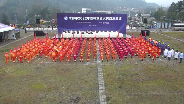
On January 6, the 2022 forest and grassland fire emergency drill was held in Qionglai City, Chengdu.
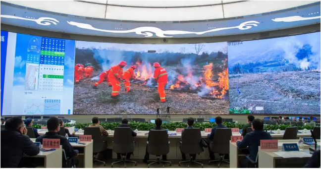
At the scene, the Chengdu Forest and Grassland Fire Fighting Headquarters received the fire report, and the emergency command system quickly researched and judged, and generated an auxiliary decision-making report with one click. The Warrior drone can quickly model the aerial photography, generate a 3D model of the fire scene in real time, and quickly carry out personnel search and rescue. The secondary identification of fire is carried out through thermal imaging technology, the fire situation is determined and the early warning message is sent in time. At the same time, the wireless image transmission system is used to push the fire location information, fire scene photos and videos to the command center, providing scientific basis for fire extinguishing research and decision-making... ...This is the 2022 Chengdu forest and grassland fire emergency drill, and it is also the emergency rescue actual combat of the Zhanlang S200 air-space-ground integrated AI command and control system integrating modernization, technology and information.

The Warrior drone transmits the picture back to the live picture of the command center
The drill was based on the background of the forest fire in Tiantai Mountain Scenic Spot in Qionglai City, where the forests are concentrated and contiguous and the forest area is complex. 200 hectares, Qionglai City Forest and Grassland Fire Fighting Headquarters immediately launched a three-level response after receiving the fire information, and organized the county, town and village three-level fire fighting forces to carry out emergency response. During the fire fighting, the wind suddenly increased and the fire spread rapidly, threatening the safety of surrounding villages and towns and the nearby Tiantai Mountain Nature Reserve. The response level of Qionglai City was raised to the first level, and the Chengdu Forest and Grassland Fire Control Headquarters launched the second level response according to the plan, and immediately adopted drone aerial reconnaissance, artificial rainfall, all-terrain vehicle force forwarding, reinforcement disposal, opening of isolation belts, Emergency measures such as special smoke point disposal of drones.
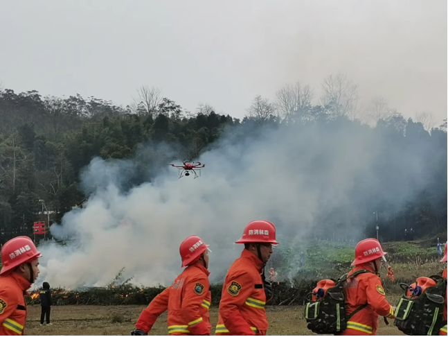
Warrior drone conducts aerial disaster reconnaissance in real time
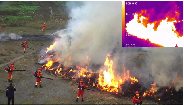
The Warrior UAV system monitors accurate data such as fire location information and fire temperature in real time
In the process of fighting the wildfire, rescuers were unable to detect the fire at close range, and the Wolf Warrior drone showed its capabilities. Obtain high-definition image data. After the data is processed by the platform, accurate data such as fire point location information, fire spread trend, wind direction change, and fire temperature can be controlled in real time.
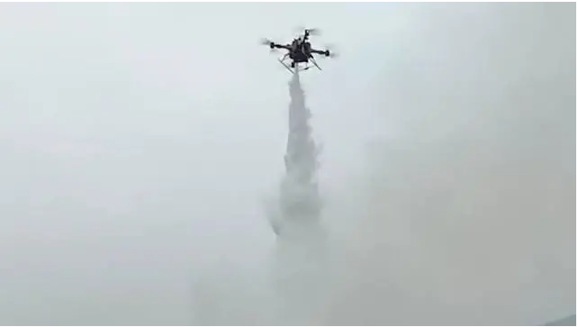
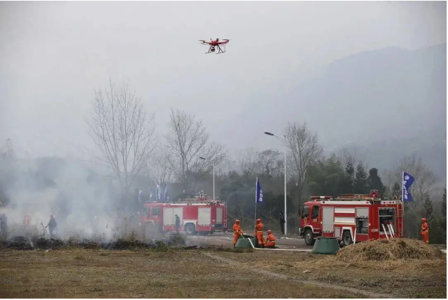
Drone extinguishing special smoke point picture
During the fight, an open fire was found on the west side of the fire field, and the firefighters could not approach the fight. The forest fire brigade used industrial drones to load dry powder fire extinguishing tanks and water-based (foam) fire extinguishing tanks to put out fire, and accurately spray dry powder fire extinguishing agent, quickly Put out the cliff fire. This method can quickly deal with cliff fires and canopy fires that are difficult for firefighters to handle, and achieve safe and efficient fire fighting.
The Warrior UAV system estimates the area of the fire field and the trend of fire spread in real time
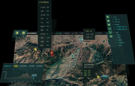
In the command of fire fighting and disaster relief, Times Starlight AI forest fire safety early warning application platform dynamically displays the topography, vegetation, materials, and geographic information of fire fighting team in real time through GIS, and broadcasts the fire situation in real time to estimate the fire area and fire intensity. Spread trend, combined with mobile weather station, push on-site meteorological information in real time, provide decision-making basis for forest fire risk prediction, fire location, forest fire fighting, decision command, post-disaster assessment, and statistical analysis and information release of disaster situations . The fire fighting plan provides a sand table to deduce the fire process, formulate fire fighting plans in advance, and quickly use historical plans or fire fighting plans when a real fire occurs, reducing the time for formulating fire fighting plans and improving command efficiency.
The Warrior UAV system generates a 3D model of the fire field in real time
Intelligently query the fire fighting route through the GIS map, display the surrounding materials, personnel, mountains, roads, rivers, etc., locate the front-line fire-fighting personnel in real time, provide an auxiliary basis for the formulation of the fire-fighting plan, and notify the front-line fire-fighting personnel of the plan in time.
Fire spread analysis
The fire spread trend is calculated through the forest fire combustion model. Based on the natural, geographical and forest conditions of the site, combined with the prevailing wind direction, wind speed and other conditions, the process of the fire spread can be visually and dynamically simulated to form a systematic forest fire behavior prediction model library.
Wind direction sudden change warning
By accessing the data of the mobile weather station, it can push the wind speed, wind direction, temperature, humidity and other information of the monitoring point in real time. When the monitoring of the on-site wind direction and wind speed change reaches the threshold, it will immediately send an early warning, which provides an important basis for the temporary command of the fire fighting site.
Real-time update of fire fighting plan
By updating and modifying the fire fighting plan, it is pushed to the fire fighting personnel in real time, replacing the complexity of the traditional plan update and issuing, and realizing the real-time update of the fire fighting plan.
Prepare forest fire emergency plan and conduct sand table fire deduction
Simulate the fire process in the 3D map, simulate the fire-fighting actions of personnel according to geographical elements, formulate a special fire-fighting plan that clearly covers personnel and materials, and formulate a fire-fighting plan according to the emergency plan after a fire occurs to respond quickly, which can verify the effectiveness of the fire-fighting plan. Make adjustments in a timely manner.
S200 air-space-ground integrated AI command and control system is used as a "smart brain" to improve decision-making efficiency. Wolf intelligent drone is equipped with a forest fire safety warning application platform to provide decision-making basis, coupled with high-tech emergency rescue such as fire-fighting drones equipment to effectively improve forest fire emergency rescue capabilities.
This exercise highlights multi-dimensional rescue. The national comprehensive fire rescue team, local professional rescue team, social rescue team, and volunteer team are assembled and pulled. A total of more than 600 people participated in the exercise, giving full play to their own advantages and realizing the integration of strength and ability. A new round of emergency preparedness for forest and grassland fire prevention has been promoted.
In the future, Chengdu Timestech Co.,Ltd will cooperate with relevant government departments to continuously improve the ability of forest fire fighting and protection. Comprehensively improve the level of emergency response to forest and grassland fires, and effectively improve emergency response capabilities and actual combat capabilities.
Chengdu Timestech Co.,Ltd is a group high-tech enterprise, mainly engaged in UAV systems, communication command vehicles, new material manufacturing, education and training, etc. The company's research and development, production and drone test flight bases cover an area of more than 300 acres! The entire industrial chain of R&D, production, system integration, and technical training will be formed into an integrated ecosystem, and a leading domestic and international brand of high-precision technology will be built. The Wolf Warrior UAV system, wireless image transmission, communication command vehicle and other products developed by Times Starlight have had a large number of cases in the fields of emergency rescue, security law enforcement, national defense military and ecological energy; it has provided a large number of cases for the government, military, security and other departments AI products and services!
The company has obtained hundreds of patented technologies, and has dozens of industry qualifications, military qualifications and honors. Strategic partner of Sichuan fire, emergency and other departments.