无人机如何赋能国土航测服务

Land and Survey Service

Quick three -dimensional model construction service


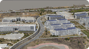
The battle wolf drone system quickly covers the scan, obtain three -dimensional data, obtain ultra -high resolution surface images and high -precision positioning data, fine and fast modeling dual -pronged approach, generate positive shooting image map, three -dimensional model map, three -dimensional surface model map, etc. Visual data, which is convenient for the development and application of various tasks and the development and application of application systems.
Get 3D data, obtain ultra -high resolution surface images, high -precision positioning data
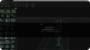
Quickly processes the positive and tilted images collected by the drone, and use airborne high-speed servers and professional software to achieve fast-moving patchwork and three-dimensional modeling, achieve 15-30 minutes of analysis results output, for on-site decision-making command, remote decision-making decision-making, remote decision-making Commands provide on -site data in a timely manner.
Quick modeling in the disaster area, rescue modeling in the risk area of chemical industry in urban areas, mountain arrests and construction models, engineering construction completion modeling
The fine three -dimensional model construction uses the three -dimensional three -dimensional three mechanism. The modeling results are high, fast, and low in cost. Modeling has measurement, fineness, and texture. Using the three -dimensional grid model to quickly restore the real environment, support the output of multiple types The format model report has massive data processing capabilities. It is suitable for long, medium and close-range targets, and scope can be completed from centimeter to kilometer. The model supports functions such as ranging, high measurement, area calculation, marking and other functions.
Fire public security jurisdiction, modeling modeling, modeling modeling of smart cities, power line planning modeling, project location selection and construction, water conservancy bridge site selection and modeling, river waters management modeling, mountain planning modeling